


# The Ultimate Guide: Understanding the Size of Vietnam Compared to the US
How big is Vietnam? When you place it next to a global giant like the United States, the difference can be surprising. The search for the size of Vietnam compared to the US reveals a fascinating story about geography, perception, and population density. This is not just about square miles on a map. It is about understanding how land area translates into real-world implications for travel, economy, and culture.
In this comprehensive guide, we will break down the exact numbers, visualize the comparison in multiple ways, and explore why the population story is just as critical as the physical size. By the end, you will have a clear, expert-level understanding of this common geographical query.
## Core Metrics: Square Kilometers and Square Miles
Let us start with the hard numbers. The most straightforward way to compare the size of Vietnam compared to the US is by total land area.
The United States, including all 50 states and the District of Columbia, covers approximately 9.8 million square kilometers (about 3.8 million square miles). It is the world’s third-largest country by land area, after Russia and Canada.
Vietnam, in contrast, has a total land area of roughly 331,210 square kilometers (about 127,880 square miles).
To make this difference crystal clear, we can do a simple calculation. You could fit Vietnam inside the continental United States nearly 30 times. Another powerful visual: Vietnam is slightly larger than the state of New Mexico but smaller than the state of California.
Here is a quick comparison table to lay out the key geographical facts:
| Metric | Vietnam | United States |
|---|---|---|
| Total Land Area | ~331,210 sq km | ~9,833,517 sq km |
| Total Land Area (sq mi) | ~127,880 sq mi | ~3,796,742 sq mi |
| Global Rank by Size | 66th | 3rd |
| Comparative US State | Larger than NM, smaller than CA | N/A |
| Coastline Length | 3,444 km (2,140 mi) | 19,924 km (12,380 mi) |
## Visualizing the Difference: Maps and Overlays
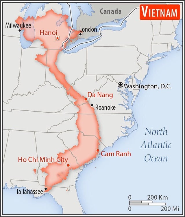
Numbers alone can be abstract. A map overlay provides an instant, intuitive grasp of the size of Vietnam compared to the US. If you were to superimpose Vietnam onto a map of the United States, its long, slender shape would stretch from the border of Georgia up to the middle of Pennsylvania. Yet its width would be relatively narrow, emphasizing its elongated geography.
This shape is crucial. Vietnam’s length creates incredible climatic diversity, from the cool northern highlands near Hanoi to the tropical Mekong Delta in the south. The United States, with its vast contiguous landmass, experiences everything from arctic conditions in Alaska to desert heat in Arizona and humid subtropical climates in the Southeast. The sheer scale of the US allows for multiple time zones and dramatically varied ecosystems within its borders, a contrast to Vietnam’s more linear variation.
## The Population Paradox: A Critical Twist
Now, here is where the comparison gets truly interesting. While the US is about 30 times larger in land area, its population is only about 3.7 times larger. This leads to a staggering difference in population density.
Vietnam is home to over 99 million people, resulting in a density of around 298 people per square kilometer. The United States, with a population of roughly 335 million, has a density of only 36 people per square kilometer. This means Vietnam is, on average, more than eight times as densely populated.
This fact fundamentally changes how one experiences space in each country. The bustling, energetic streets of Hanoi or Ho Chi Minh City feel a world apart from the sprawling suburbs and wide-open spaces common in many American states. When considering the size of Vietnam compared to the US, the population density is the hidden variable that explains daily life, infrastructure pressure, and agricultural land use.
## A Traveler’s Perspective: Distance and Journey Times
For travelers, these size differences have practical implications. Driving from the northern tip of Vietnam to the southern tip, a journey of roughly 1,650 kilometers, might take over 30 hours of continuous driving. Crossing the United States from New York to Los Angeles is a monumental trip of about 4,500 kilometers, requiring over 40 hours of non-stop driving.
However, the experience differs. Vietnam’s journey would take you through constantly changing landscapes and dense networks of towns along a few main arteries. The US cross-country trip involves long stretches of highway through vast, relatively empty landscapes between major metropolitan hubs. This contrast highlights how infrastructure and land use adapt to both size and population distribution.
## Economic and Agricultural Land Use
Land area directly influences economic potential. The United States possesses enormous tracts of arable land, making it a global agricultural powerhouse. Vietnam, with a much smaller total area, utilizes a significantly higher percentage of its land for agriculture—over 40% compared to about 17% in the US—through intensive farming, especially in the rice-producing deltas.
From an industrial and development perspective, the US has the space for large-scale manufacturing plants, extensive highway systems, and sprawling logistics hubs. Vietnam’s development is often more vertical and concentrated, with industrial zones strategically placed to maximize limited flat land. Understanding the size of Vietnam compared to the US is essential for grasping the constraints and opportunities in each nation’s economic growth story.
## Common Misconceptions and Errors
A frequent mistake when comparing countries is to look only at the map in a standard atlas, which often uses the Mercator projection. This projection drastically distorts the size of landmasses closer to the poles, making countries like the US, Canada, and Russia appear much larger relative to equatorial nations than they actually are. While Vietnam is still vastly smaller, using a tool like The True Size website to drag countries over one another provides a much fairer visual comparison.
Another error is forgetting the non-contiguous parts of the US. Alaska alone is massive, at 1.7 million square kilometers. If you compared Vietnam just to the contiguous 48 states, the US is still about 27 times larger, but including Alaska and Hawaii changes the scale. Always confirm which territorial definitions are being used in any comparison you read.
## How to Accurately Compare Any Two Countries: A 5-Step Guide
If you want to move beyond Vietnam and the US and compare any two nations accurately, follow this simple guide.
STEP 1: IDENTIFY YOUR METRIC. Decide what you are comparing: total land area, population, density, economic output per square kilometer, or coastline length.
STEP 2: USE AUTHORITATIVE SOURCES. Go to trusted databases like the World Bank, the CIA World Factbook, or the United Nations for standardized, verified data.
STEP 3: NORMALIZE THE UNITS. Ensure all figures are in the same measurement system, either metric or imperial, for a clear comparison.
STEP 4: CONSIDER THE CONTEXT. Ask why the size matters. For economics, consider GDP per capita alongside area. For ecology, look at biodiversity per unit of land.
STEP 5: VISUALIZE WITH TOOLS. Use digital tools like map overlays or infographic generators to create a visual representation that makes the data intuitive.
According to my experience in geographic analysis, skipping Step 4 is the most common error. People get the raw numbers but fail to understand what they mean for the people living there. For instance, a 2023 World Bank report highlights that despite its smaller size, Vietnam’s agricultural yield per hectare for rice is among the highest in the world, a direct result of adapting to land constraints.
## Final Checklist for Understanding Geographic Comparisons
To ensure you have a complete and nuanced understanding of any country size comparison, use this checklist. Review each point after your research.
– Verified land area data from a primary source like the CIA World Factbook is obtained.
– Population figures and density calculations are included in the analysis.
– The geographic shape and terrain of each country are considered for context.
– Map projection distortions are acknowledged and corrected for with modern tools.
– Practical implications for travel, economy, or culture are identified and explained.
– The comparison is framed to answer a specific “so what?” question, moving beyond mere numbers.
In conclusion, the exploration of the size of Vietnam compared to the US is a gateway to deeper insights. It is a tale of two nations where one’s vast expanse contrasts with the other’s concentrated vitality. By looking beyond the initial shock of the scale difference and diving into population, density, and real-world implications, we gain a true appreciation for how geography shapes destiny. Whether you are a student, a traveler, or a business professional, keeping this holistic view in mind will make you a more informed global citizen.


